
 1 month ago
84
1 month ago
84
PROTECT YOUR DNA WITH QUANTUM TECHNOLOGY
Orgo-Life the new way to the future Advertising by AdpathwayDisclaimer: This site is not affiliated with the National Hurricane Center, Hurricane Hunters, Storm Prediction Center, or National Weather Service. ALL forecasts herein are the result of my analysis, (to which you will see me at times, insert excerpts from various agencies due to the nature of the importance of the information) and I am solely responsible for the content. As ALWAYS, follow the National Hurricane Center, National Weather Service, and your local Emergency Management officials for emergency decisions. In addition, this is strictly a FORECAST OFFICE. I CANNOT make decisions regarding travel plans, etc. My purpose, is to provide you the information, based solely on information I analyze, and the accuracy of the information at hand of the time of analysis, so you may make informed decisions.
(T. F. “Storm” Walsh)
For those who have donated to my site, your help has been greatly appreciated. If you are not aware, donations to my site help pay for subscriptions to sites I use as well as software updates, which provide all the models and information used in my forecasts. To donate, please click the DONATE button to the right side of the page, or on the graphic of the dog. Any help you provide is immensely appreciated!
DONATIONS ACCEPTED AND APPRECIATED


I will reiterate, my forecasts are based on the available information at the time of analysis, and are only as accurate as the information analyzed and the solutions provided.
Good evening everyone!
In analysis of severe weather this morning, I had looked at some tropical maps, and the ECMWF EPS Tropical Cyclone Probability forecast map caught my eye. The forecast has initiated a 10% probability for cyclone development off the OBX for May 02, due to a coastal low forecast to develop. In this forecast, I will utilize the ECMWF model given it has proven more accurate during my years of forecasting.
CONUS SATELLITE LOOP
Based on analysis of MSLP animations from the ECMWF global model, a low pressure system is forecast to develop off the SEUS / OBX COAST on Saturday. The ECMWF EPS Cyclone Formation Probability forecast has latched onto this for the past 2 days with an initial 5% probability, and having increased to 10% as of today.
ECMWF EPS CYCLONE FORMATION PROBABILITY FORECAST

Based on my analysis this afternoon, I do not expect any tropical development of this system. Although there are some favorable features in the forecast [ample surface to mid level RH, weak divergence aloft based on CHI200 forecast anomalies indicating upward motion (green shading), and the system being within the Right Rear Entrance Region of the jetstream (provides upper divergence)], negative factors include low PWAT (Precipitable WATer), SST’s of 22C – 23C, high wind shear, and lack of outflow at the 200 mb level. Based on the colder SST’s, the current Cyclone Phase Diagram keeps this system a Cold Core system. The favorable factors however will allow for the low to intensify as it moves off the the NE.
Depending on how conditions actually come together, this low could have the potential to produce minimal Tropical Storm force winds near the coastal area of the OBX (Outer Banks) of NC, with possible higher gusts. As the system progresses NE, it will intensify and could produce winds of mid grade Tropical Storm force, with higher gusts.
Seas near the coast of the OBX may reach 5 – 6 ft., with seas well offshore forecast to reach 7 – 12 ft., with maximum individual wave heights being much higher.
ECMWF MSLP ANIMATION FORECAST
CURRENT ECMWF SURFACE WIND AND WIND GUSTS FORECAST 

ECMWF SIGNIFICANT WAVE HEIGHT AND DIRECTION FORECAST
SEA SURFACE TEMPERATURES
WIND SHEAR FORECAST
CHI200 ANOMALIES FORECAST
ECMWF CYCLONE PHASE THERMAL DIAGRAM
Residence within the area of onshore wind flow could experience some minor coastal flooding and possible minor beach erosion. I recommend small craft remain in port, and residence remain away from the water until this system passes. It is recommended that commercial shipping remain alert and avoid the area if possible by taking evasive action.
Based on the SPC forecast for severe weather during the next 2 days, the severe weather will take precedence. IF possible, I will try to update on this system tomorrow evening.
The following links will connect you to the Excessive Rainfall probabilities and River Flood Outlook:
EXCESSIVE RAINFALL
https://www.wpc.ncep.noaa.gov/qpf/excessive_rainfall_outlook_ero.php
SIGNIFICANT RIVER FLOOD OUTLOOK
https://www.wpc.ncep.noaa.gov/nationalfloodoutlook/index.html
The following NWS Watch / Warning map will provide local NWS information for your area. Click the image, then once it refreshes, click on your area of interest to view any forecasts, watches / warnings, special weather statements, hazards or advisories for your area.
NWS WATCH / WARNING DISPLAY (LINKED…CLICK MAP, THEN YOUR AREA)
NWS DOPPLER RADAR LOOP (LINKED, CLICK RADAR MAP)
RAP RADAR (CLICK IMAGE THEN GO TO LOOP DURATION AND PICK LENGTH OF LOOP, THEN CLICK RADAR SITE)
WUNDERGROUND RADAR SUMMARY MAP (CLICK FOR UPDATES)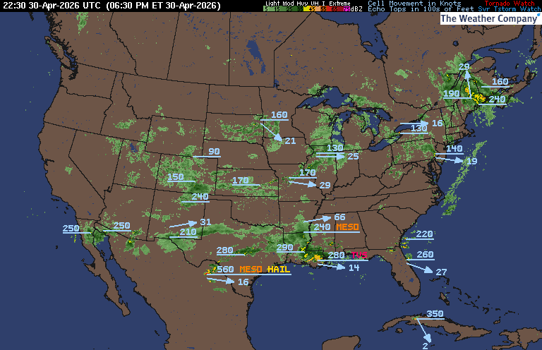
PRECIPITATION TYPE (CLICK TO ACCESS ANIMATION FEATURE)
CARIBBEAN RADAR (CLICK IMAGE TO ACCESS ANIMATION) You may direct any questions by contacting me personally, ANYTIME, at: twalsh22000@yahoo.com
Have a blessed evening!
T. F. “STORM” WALSH III GMCS, USCG (ret)
METEOROLOGIST / HURRICANE SPECIALIST /SEVERE WEATHER SPECIALIST
COCORAHS OBSERVER


 English (US) ·
  French (CA) ·