
 5 months ago
220
5 months ago
220
PROTECT YOUR DNA WITH QUANTUM TECHNOLOGY
Orgo-Life the new way to the future Advertising by AdpathwayDisclaimer: This site is not affiliated with the National Hurricane Center, Hurricane Hunters, Storm Prediction Center, or National Weather Service. ALL forecasts herein are the result of my analysis, (to which you will see me at times, insert excerpts from various agencies due to the nature of the importance of the information) and I am solely responsible for the content. As ALWAYS, follow the National Hurricane Center, National Weather Service, and your local Emergency Management officials for emergency decisions. In addition, this is strictly a FORECAST OFFICE. I CANNOT make decisions regarding travel plans, etc. My purpose, is to provide you the information, based solely on information I analyze, and the accuracy of the information at hand of the time of analysis, so you may make informed decisions.
(T. F. “Storm” Walsh)
Thanks to all of you that still follow my forecasts. I truly appreciate each and every one of you!
For those who have donated to my site, your help has been greatly appreciated. If you are not aware, donations to my site help pay for subscriptions to sites I use as well as software updates, which provide all the models and information used in my forecasts. To donate, please click the DONATE button to the right side of the page, or on the graphic of the dog. Any help you provide is immensely appreciated!
DONATIONS NEEDED AND APPRECIATED


I will reiterate, my forecasts are based on the available information at the time of analysis, and are only as accurate as the information analyzed and the solutions provided.
Good day everyone!
As of this morning, the Storm Prediction Center does not indicate any severe weather probabilities for the week until DAY 5, Friday Jan. 09, currently indicating a SLIGHT risk probability. The CSU – MLP and NSSL ML severe weather guidance forecast does however suggest a possibility for a MARGINAL risk by Thu Jan. 08, as well as the probabilities for the 9th. I will continue to monitor this as we go through the week and will try to issue a severe weather synopsis should this occur.
STORM PREDICTION CENTER (SPC) DAY 5 SEVERE WEATHER OUTLOOK (LINKED)

CSU – MLP / NSSL ML DAY 4 AND DAY 5 SEVERE WEATHER FORECAST MAPS (LINKED FOR LARGER IMAGES)


The following is an excerpt from the current DAY 5 outlook discussion from the SPC:
The noticeable model differences on D3/Wednesday in the evolution of a low-latitude shortwave impulse, ejecting ahead of an amplifying upper trough over the West, persist into D4/Thursday. This renders low confidence in a greater than low-probability severe risk on Thursday, which appears roughly centered on the Ark-La-Tex to Mid-South.
Peak severe potential still appears centered on D5/Friday. Predictability remains sub-optimal with the basal portion of the amplified upper trough from the Southwest. This renders large spread across guidance in timing and amplitude of downstream cyclogenesis from the south-central Great Plains towards the Great Lakes, impacting the breadth of severe potential. However, with preceding days of airmass modification from the western Gulf, a pronounced wintertime warm-moist sector should become established towards the Lower OH Valley vicinity. This should be coincident with a broad swath of strong southwesterly mid-level flow that should be strengthening during the period.
The trio of latest NCAR ECENS-based and SPC-CSU GEFS-based ML probabilities have trended upward again with similarly large 15 percent regions. Meanwhile, the NSSL GEFS-based V1.2 has increased back to a 10 percent, but displaced farther south. For this forecast, have opted to include a 15 percent highlight, centered on the Lower MS to Lower OH Valleys where confidence is greater for a favorable convective environment on Friday afternoon to night despite the modest synoptic-scale predictability.
WINTER WEATHER
I prefer using the ECMWF model for the main forecast graphics for winter weather forecasts. Over my years of forecasting, I prefer this model, as numerous articles depict the ECMWF to be the more accurate model as compared to the GFS. Here is an excerpt from an article I found:
The ECMWF model’s resolution is 9km or about 5.5 miles. The GFS has a resolution of 25km or roughly 15.5 miles. This resolution is the distance between two points on a grid that the weather model uses. The smaller the number, the better the resolution/quality of a forecast. The European Center for Medium-Range Weather Forecasts (ECMWF) model is another global numerical weather prediction model that is highly regarded for its accuracy. It employs advanced data assimilation techniques and sophisticated numerical algorithms to simulate atmospheric processes. The ECMWF model provides high-resolution forecasts for various meteorological variables, enabling forecasters to make more precise predictions. According to current weather forecasting standards, the ECMWF model is generally considered the most accurate for predicting snowfall totals, often performing slightly better than American weather models like the GFS.
For forecast temperatures less than 72 hours out in the forecast period, I prefer using the NAM (North American Mesoscale) model. This is what we refer to as a regional model, vice a global model, with its forecast grids within the North American continent. The NAM 3km only goes out to 60 hours, and the NAM 12km goes out to 84 hours.
Should a forecast indicate very cold temperatures, or cold snowy weather:

The following link is from the Animal Welfare Act, and provides guidelines for temperatures regarding your animal:
ANIMAL WELFARE ACT
https://www.aphis.usda.gov/sites/default/files/ac-tech-note-temp-req-dogs.pdf
UNITED STATES SATELLITE LOOP

WPC 12Z SURFACE MAP (LINKED TO SURFACE MAP/RADAR ANIMATION)

Based on analysis of the stratosphere charts, we are currently NOT in a SSW phase. Should the forecast indicate another occurrence, it will be included.
ECMWF 10 MB TEMPERATURE AND PRESSURE ANOMALIES


As we move through the week, I do not at the moment expect any significant changes to the fluctuation of cold air, until after mid month, when the current forecast indicates some very cold Arctic air once again coming south around the 17th – 19th of the month. Again, the temperature pattern will continue to fluctuate during the next 5 days. Thereafter, some heavy snowfall is being shown for some portions of the central U.S., and especially over the Great Lakes and NE regions of the U.S. I will try to balance these forecasts between severe weather and winter weather. However, severe weather will take precedence.
ECMWF 5 DAY TEMPERATURE ANIMATION


ECMWF MINIMUM TEMPERATURE FORECAST JAN. 19, 2026


The following are minimum temperatures for the succeeding day from the issuance of this synopsis:
MINIMUM AND APPARENT TEMPERATURES JAN. 06, 2026


APPARENT


WUNDERGROUND FROST AND FREEZE FORECAST FOR JAN. 06, 2025
 The following NWS Watch / Warning map will provide local NWS information for your area. Click the image, then once it refreshes, click on your area of interest to view forecasts, any special weather statements, hazards or advisories for your area.
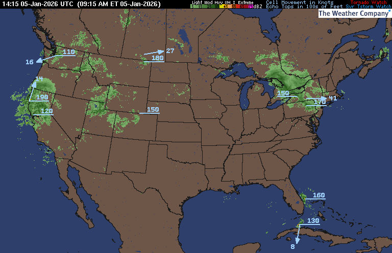
NWS WATCH / WARNING DISPLAY (LINKED…CLICK MAP, THEN YOUR AREA) NWS DOPPLER RADAR LOOP (LINKED, CLICK RADAR MAP)
 RAP RADAR (CLICK IMAGE THEN GO TO LOOP DURATION AND PICK LENGTH OF LOOP, THEN CLICK RADAR SITE)
 WUNDERGROUND RADAR SUMMARY MAP (CLICK FOR UPDATES)
PRECIPITATION TYPE (CLICK TO ACCESS ANIMATION FEATURE) CARIBBEAN RADAR (CLICK IMAGE)
 You may direct any questions by contacting me personally, ANYTIME, at: twalsh22000@yahoo.com
Have a blessed day!
T. F. “STORM” WALSH III
GMCS, USCG (ret)
METEOROLOGIST / HURRICANE SPECIALIST /SEVERE WEATHER SPECIALIST


 English (US) ·
  French (CA) ·