
 5 months ago
141
5 months ago
141
PROTECT YOUR DNA WITH QUANTUM TECHNOLOGY
Orgo-Life the new way to the future Advertising by AdpathwayDisclaimer: This site is not affiliated with the National Hurricane Center, Hurricane Hunters, Storm Prediction Center, or National Weather Service. ALL forecasts herein are the result of my analysis, (to which you will see me at times, insert excerpts from various agencies due to the nature of the importance of the information) and I am solely responsible for the content. As ALWAYS, follow the National Hurricane Center, National Weather Service, and your local Emergency Management officials for emergency decisions. In addition, this is strictly a FORECAST OFFICE. I CANNOT make decisions regarding travel plans, etc. My purpose, is to provide you the information, based solely on information I analyze, and the accuracy of the information at hand of the time of analysis, so you may make informed decisions.
(T. F. “Storm” Walsh)
For those who have donated to my site, your help has been greatly appreciated. If you are not aware, donations to my site help pay for subscriptions to sites I use as well as software updates, which provide all the models and information used in my forecasts. To donate, please click the DONATE button to the right side of the page, or on the graphic of the dog. Any help you provide is immensely appreciated!
DONATIONS ACCEPTED AND APPRECIATED


I will reiterate, my forecasts are based on the available information at the time of analysis, and are only as accurate as the information analyzed and the solutions provided.
Good day everyone!
As a precaution, I may not be able to post on my Facebook account soon, as FB is requiring I set up 2 step verification, to which I have run into problems getting this setup. I will continue to try and resolve this issue. SHOULD I lose access, those who wish to continue viewing my forecasts, PLEASE send an email to the email address at the end of this synopsis, to be added to email distribution, which will be sent to you blind carbon copy. Thank you for your understanding
The Storm Prediction Center (SPC) has issued a MARGINAL risk for severe thunderstorms in the current DAY 3 Outlook: PORTIONS OF THE LOWER OHIO AND TENNESSEE VALLEYS…
…SPC SUMMARY…
Isolated damaging wind gusts are possible across portions of the Lower Ohio and Tennessee Valleys on Thursday.
SPC DAY 3 SEVERE THUNDERSTORM OUTLOOK (LINKED FOR OUTLOOK TEXT)

The following is the day 3 outlook from the CSU – MLP severe weather forecast map vs the SPC forecast, with the CSU indicating a possible upgrade to a slight risk:
CSU – MLP DAY 3 FORECAST (CLICK FOR LARGER IMAGE)

DAY 3 PROBABILITY CONVERSION TABLE
SPC DISCUSSION EXCERPT:
A line of convection will likely be in its infancy along the cold front in Illinois and Missouri at the beginning of the period. Low-level moisture will continue to advect north ahead of this cold front and result in some weak destabilization. The mid-50s dewpoints will likely struggle to make it north of the Ohio River given the snowpack across the region, despite very strong low-level moisture advection. However, south of this snowpack there will likely be a zone where the strong forcing along the cold front can overcome only marginally unstable surface parcels. This strongly forced convective line amid 60-70 knots of background flow (as low as 1km) will support isolated damaging wind gusts through the afternoon.
Greater instability is expected south of the TN/MS/AL border where upper 50s to low 60s dewpoints are forecast. However, despite the more favorable thermodynamics, the upper-level forcing will be weaker. Therefore, it is unclear whether the line of storms will continue that far south, and additional convection ahead of the front will likely struggle given the weak lapse rates/minimal heating.
Based on analysis of some severe forecast indices and parameters, the atmosphere is currently forecast to be fairly stable, with current forecast mid level lapse rates at around 4.5 – 5.0 C/km, and lack of negative lifted indices. The main threat for Thursday appears to be the possibility of damaging wind gusts, based on bulk wind shear of around 50 – 60 kts. Given the marginal risk is still 48+ hours out in the forecast period and some severe parameters are not available, I intend on providing an updated forecast with severe indices and parameters, NADOCAST forecast maps, along with the NAM 3KM and HRRR 3KM animations, as current severe parameter values are either very weak or not even registering. On Thursday, everything should be current for that day, and I should have the complete set.
The following links will connect you to the Excessive Rainfall probabilities and River Flood Outlook:
EXCESSIVE RAINFALL
https://www.wpc.ncep.noaa.gov/qpf/excessive_rainfall_outlook_ero.php
SIGNIFICANT RIVER FLOOD OUTLOOK
https://www.wpc.ncep.noaa.gov/nationalfloodoutlook/index.html
The following NWS Watch / Warning map will provide local NWS information for your area. Click the image, then once it refreshes, click on your area of interest to view any special weather statements, hazards or advisories for your area.
NWS WATCH / WARNING DISPLAY (LINKED…CLICK MAP, THEN YOUR AREA)
NWS DOPPLER RADAR LOOP (LINKED, CLICK RADAR MAP)
RAP RADAR (CLICK IMAGE THEN GO TO LOOP DURATION AND PICK LENGTH OF LOOP, THEN CLICK RADAR SITE)
WUNDERGROUND RADAR SUMMARY MAP (CLICK FOR UPDATES)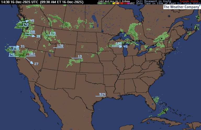
PRECIPITATION TYPE (CLICK TO ACCESS ANIMATION FEATURE)
CARIBBEAN RADAR (CLICK IMAGE TO ACCESS ANIMATION)
You may direct any questions by contacting me personally, ANYTIME, at: twalsh22000@yahoo.com
Have a blessed day!
T. F. “STORM” WALSH III
GMCS, USCG (ret)
METEOROLOGIST / HURRICANE SPECIALIST /SEVERE WEATHER SPECIALIST


 English (US) ·
  French (CA) ·