
 4 months ago
115
4 months ago
115
PROTECT YOUR DNA WITH QUANTUM TECHNOLOGY
Orgo-Life the new way to the future Advertising by AdpathwayDisclaimer: This site is not affiliated with the National Hurricane Center, Hurricane Hunters, Storm Prediction Center, or National Weather Service. ALL forecasts herein are the result of my analysis, (to which you will see me at times, insert excerpts from various agencies due to the nature of the importance of the information) and I am solely responsible for the content. As ALWAYS, follow the National Hurricane Center, National Weather Service, and your local Emergency Management officials for emergency decisions. In addition, this is strictly a FORECAST OFFICE. I CANNOT make decisions regarding travel plans, etc. My purpose, is to provide you the information, based solely on information I analyze, and the accuracy of the information at hand of the time of analysis, so you may make informed decisions.
(T. F. “Storm” Walsh)
For those who have donated to my site, your help has been greatly appreciated. If you are not aware, donations to my site help pay for subscriptions to sites I use as well as software updates, which provide all the models and information used in my forecasts. To donate, please click the DONATE button to the right side of the page, or on the graphic of the dog. Any help you provide is immensely appreciated!
DONATIONS ACCEPTED AND APPRECIATED


I will reiterate, my forecasts are based on the available information at the time of analysis, and are only as accurate as the information analyzed and the solutions provided.
Good day everyone!
Due to the nature of today’s severe weather outlook, as storms are already ongoing, with the strongest activity forecast to occur from now, through 18Z (12:00 NOON CST) this synopsis will be greatly abbreviated, and will not contain the indices portion and such, in order to get this published in a timely manner due to the nature of one or two isolated STRONG tornadoes
The Storm Prediction Center (SPC) has issued a SLIGHT risk for severe thunderstorms in the current DAY 1 Outlook: THIS MORNING AND EARLY AFTERNOON FROM CENTRAL LOUISIANA TO WESTERN GEORGIA…
…SPC SUMMARY…
A few severe thunderstorms are forecast this morning and early afternoon from LA/MS into AL/GA.
SPC DAY 1 SEVERE THUNDERSTORM OUTLOOK (LINKED FOR OUTLOOK TEXT)
TORNADO PROBABILITY
Probability of a tornado within 25 miles of a point.
HAIL PROBABILITY
Probability of one inch diameter hail or larger within 25 miles of a point.
DAMAGING THUNDERSTORM WIND PROBABILITY
Probability of damaging thunderstorm winds or wind gusts of 50 knots or higher within 25 miles of a point.
CSU – MLP DAY 1 FORECAST (CLICK FOR LARGER IMAGE)
NSSL ML PROBABILITY DAY 1

DAY1 PROBABILITY CONVERSION TABLE
SPC DISCUSSION EXCERPT:
…LA/MS/AL/GA…
Strong and deep southwesterly flow is present today over much of the southeast US, with a well-defined baroclinic zone extending from central LA across parts of MS/AL into northern GA. Thunderstorms have been intensifying in the past few hours across southeast MS, where multiple supercell structures and a couple of confirmed tornadoes have occurred. This activity is expected to persist for several more hours, tracking across parts of central AL and eventually into western GA. Low-level winds and shear have become sufficiently strong to support risk of a strong tornado or two along this corridor.
The following maps are from NADOCAST for tornado and hail probabilities.
00Z NADOCAST TORNADO PROBABILITY (CLICK FOR LARGER IMAGE)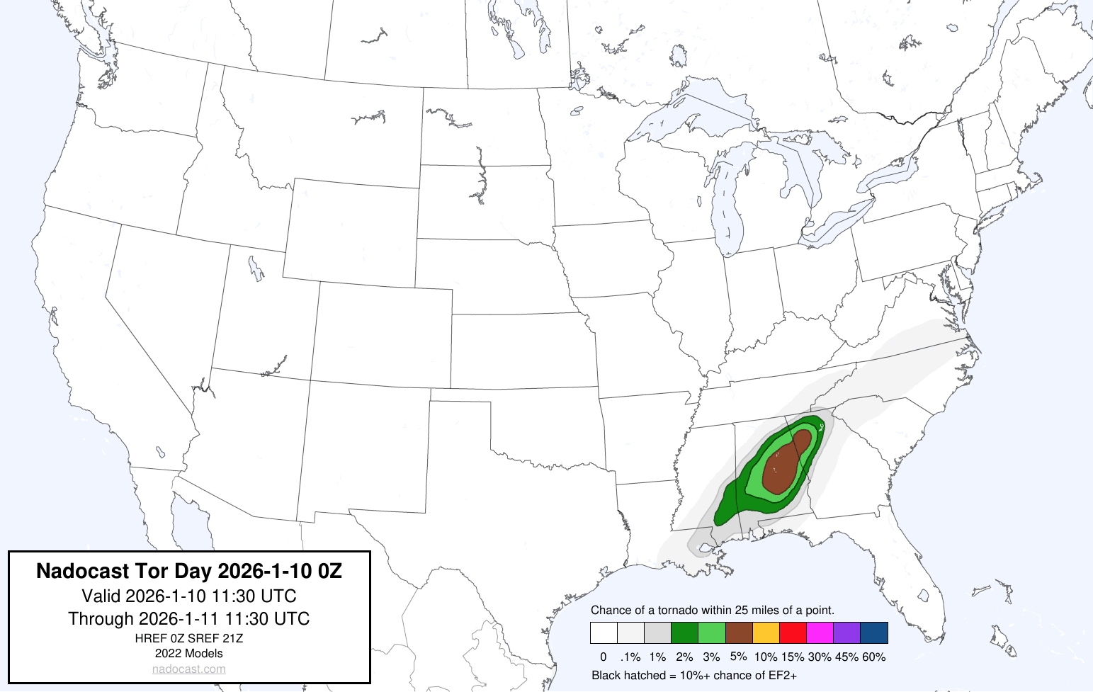
00Z NADOCAST SIGTOR PROBABILITY (CLICK FOR LARGER IMAGE)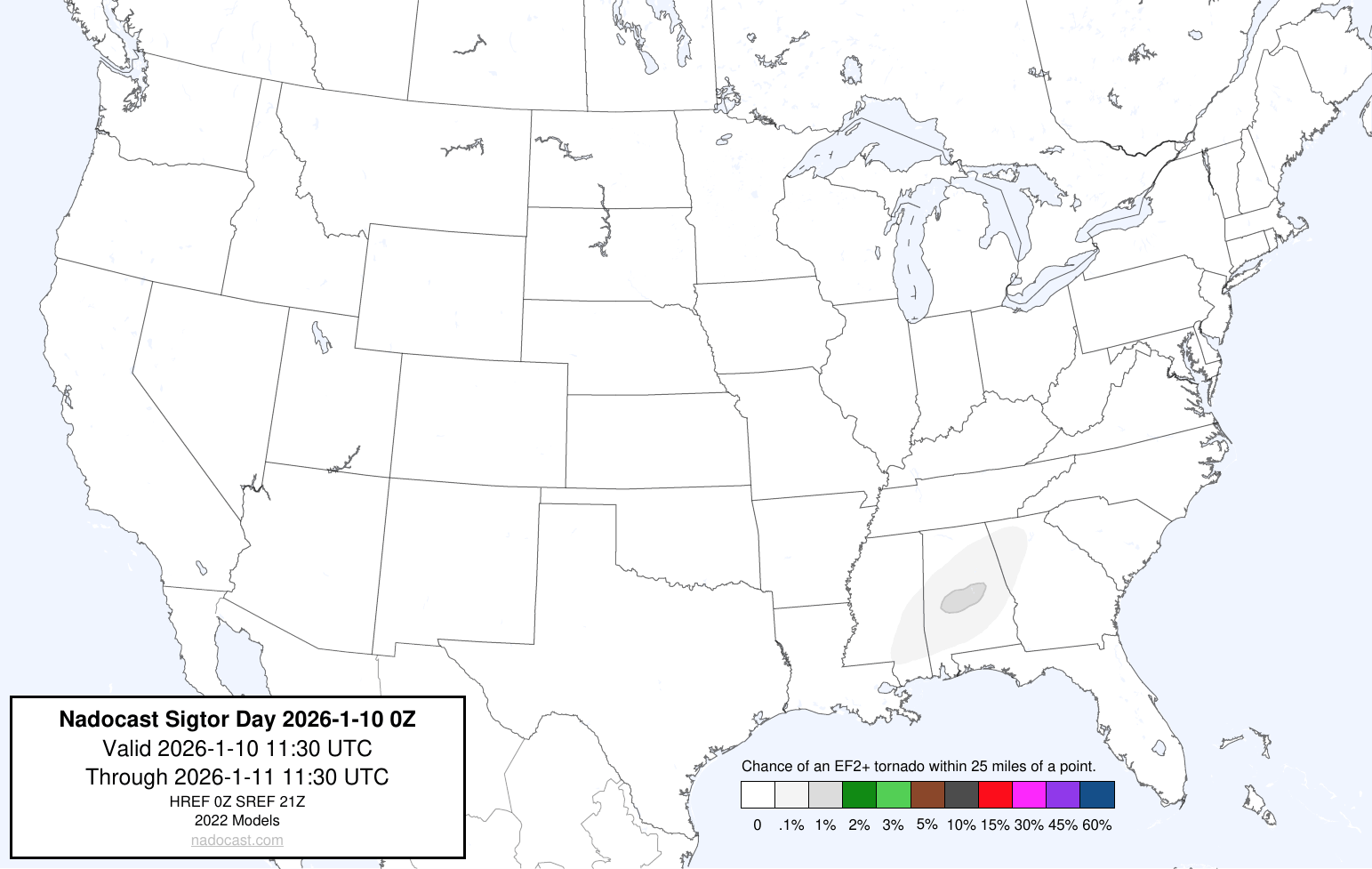
00Z NADOCAST HAIL PROBABILITY (CLICK FOR LARGER IMAGE)
00Z NADOCAST SIGHAIL PROBABILITY (CLICK FOR LARGER IMAGE)
Storms were already in progress from earlier this morning and continue t0 progress eastward and strengthen. A quick look at some indices indicate a probability for and isolated strong tornado or two, with the strongest forecast indices shown to be over the SLIGHT RISK and 5% TORNADO OUTLINE over Alabama. Tornado watches have been issued.
Based on analysis of model animations, the current outlook, and analysis of indices, the strongest convection and indices should occur approximately between NOW through 12:00 NOON CST today, with strong storms progressing into Georgia. These storms appear to begin to weaken by approximately 4:00 – 5:00 p.m. EST. Please visit the SPC homepage via the link provided for any changes to the forecast today.
The following are the SCP (Supercell Composite Parameter) and STP (Significant Tornado Parameter) forecast maps from the NAM 3KM model. Generally, the higher the values and brighter the color, indicates a greater probability of strong thunderstorm and / or tornadic activity over an area:
NAM 3KM SCP FORECAST 6:00 A.M. CST JAN. 10 – 4:00 P.M. EST JAN. 10
NAM 3KM STP FORECAST 6:00 A.M. CST JAN. 10 – 4:00 P.M. EST JAN. 10
Please use the following maps, which should update automatically, for Mesoscale Discussions and Convective Watches. You may have to refresh your browser, or click on the graphics. I have provided the SPC homepage link below, so you may get the updated information regarding any changes to the outlook:
https://www.spc.noaa.gov/classic.html
SPC MESOSCALE DISCUSSIONS (CLICK IMAGE FOR UPDATES)
SPC CONVECTIVE WATCHES (CLICK IMAGE FOR UPDATES)
IF A TORNADO WARNING IS ISSUED FOR YOUR AREA, TAKE IMMEDIATE SAFE AND STURDY SHELTER!
The following sites will explain most of the severe weather and tornado values listed above, and will give you an idea of what to expect:
ENVIRONMENTAL INDICES AND PARAMETERS NWS
https://www.weather.gov/lmk/indices
THE WEATHER PREDICTION
http://www.theweatherprediction.com/severe/indices/
The following links will connect you to the Excessive Rainfall probabilities and River Flood Outlook:
EXCESSIVE RAINFALL
https://www.wpc.ncep.noaa.gov/qpf/excessive_rainfall_outlook_ero.php
SIGNIFICANT RIVER FLOOD OUTLOOK
https://www.wpc.ncep.noaa.gov/nationalfloodoutlook/index.html
The following NWS Watch / Warning map will provide local NWS information for your area. Click the image, then once it refreshes, click on your area of interest to view forecasts, any special weather statements, hazards or advisories for your area.
NWS WATCH / WARNING DISPLAY (LINKED…CLICK MAP, THEN YOUR AREA)
NWS DOPPLER RADAR LOOP (LINKED, CLICK RADAR MAP)
RAP RADAR (CLICK IMAGE THEN GO TO LOOP DURATION AND PICK LENGTH OF LOOP, THEN CLICK RADAR SITE)
WUNDERGROUND RADAR SUMMARY MAP (CLICK FOR UPDATES)
PRECIPITATION TYPE (CLICK TO ACCESS ANIMATION FEATURE)
CARIBBEAN RADAR (CLICK IMAGE TO ACCESS ANIMATION)
You may direct any questions by contacting me personally, ANYTIME, at: twalsh22000@yahoo.com
Have a blessed day!
T. F. “STORM” WALSH III
GMCS, USCG (ret)
METEOROLOGIST / HURRICANE SPECIALIST /SEVERE WEATHER SPECIALIST


 English (US) ·
  French (CA) ·